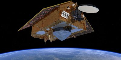
 Artist’s impression of the Sentinel-6 satellite.
Photo: ESA/ATG medialab
Sea level rise is one of the most immediate effects of climate change, as evidenced recently by urgent appeals from island leaders at the COP26 summit. Global measurements of sea-level rise are essential to support global policies and strategies to protect coastal and low-lying areas. Measuring subtle differences in sea level height from space is no easy task – but that’s exactly what the Copernicus Sentinel-6 Michael Freilich satellite does. After a year of rigorous testing, this new mission now provides the world’s most accurate sea-level rise data.
Copernicus Sentinel-6 Michael Freilich, launched on November 21, 2020, uses the latest radar altimetry technology developed by the European Space Agency (ESA) to set a long-term record for sea-surface height measurements, which began in 1992 with the French-American Topex satellite. Poseidon and Jason’s series of satellite missions followed.
With monitoring of sea level rise high on the global agenda, many organizations have been involved in the effort to make Copernicus Sentinel-6 a gold standard reference mission for making future sea level rise measurements more accurately than ever before. While the Sentinel-6 is part of the European Union’s Copernicus missions, its implementation is the result of exceptional cooperation between the European Commission ESA, Eumetsat, NASA and NOAA, with support from the French space agency CNES.
Eumetsat, the European organization for the exploitation of meteorological satellites, is responsible for operating the satellite and making data available to users. The first data products, which were low-resolution products, were released in June. This was an important step in the transition to the high-resolution products now being launched. The data has been used for weather forecasting and seasonal forecasting models, and for forecasting the development and course of hurricanes.
The Sentinel-6’s Poseidon-4 altimeter is designed to integrate new high-precision Ku-band synthetic aperture radar measurements into the altimeter reference time series. Thus, it provides both low-resolution and high-resolution measurements at the same time. The low-resolution measurements are matched with those of the mission’s predecessor, Jason-3, and are therefore essential for continuity, and the enhanced high-resolution data can then be presented with absolute certainty.
To ensure that the differences between the low-resolution historical time series and the new data from Copernicus Sentinel-6 Michael Freilich were fully understood, a 12-month tandem flight was conducted. The Sentinel-6 flies 30 seconds behind its predecessor, Jason-3, and follows the same path on the ground. After months of rigorous testing, a high-resolution data stream from Copernicus Sentinel-6 is now available. Giulia Vega Saldana, Eumetsat Ocean Altimeter Program Manager, said: “Experts from around the world have checked and verified the data, confirming that the Copernicus Sentinel-6 mission is extremely robust, accurate and reliable. Closer to 1mm with its predecessor Jason-3 ensures the 30-year record Average sea level, as recorded by satellite radar altimeters, continues uninterrupted.
“The data released today is crucial to monitoring the impact of climate change on Earth’s oceans.” ESA Sentinel-6 mission scientist Craig Donlon added: “Measurements of sea-level rise provide a unique and integrated picture of climate change, as warming oceans and increasing land-ice melt lead to sea-level rise.
Sentinel-6 Michael Freilich safely brings new synthetic aperture radar measurement technology to the time series of a reference altimeter for the first time. This enables Sentinel-6 to offer improved measurements of sea conditions and wind speed, and improved capabilities for river and lake hydrology applications, while sea-level rise estimates are kept stable. These measurements provide crucial evidence for developing and implementing strong community policies for our future. “
Copernicus Sentinel-6 Project Manager at ESA, Pierrik Vuilleumier commented: “The collaboration with NASA, EUMETSAT, NOAA and CNES has paid off today with the timely launch of mission products for operational users, providing continuity of previous reference missions as well as new missions. High-precision synthetic aperture radar products. The digital technology of the Poseidon-4 altimeter provides an unprecedented level of performance.”
“While the Sentinel-6 exceeds expectations in orbit for Michael Freilich, we are busy with its successor, Sentinel-6B. The satellite is now at IABG facilities in Ottobrunn, Germany, where it is undergoing an environmental test campaign until March next year. It will be stored mid-year until We are preparing it for launch at the end of 2025.”
Source: This is amazing

“Total coffee specialist. Hardcore reader. Incurable music scholar. Web guru. Freelance troublemaker. Problem solver. Travel trailblazer.”


More Stories
GALA lacks a chapter on e-health
Weird beer can taste really good.
Planets contain much more water than previously thought