© Shutterstock
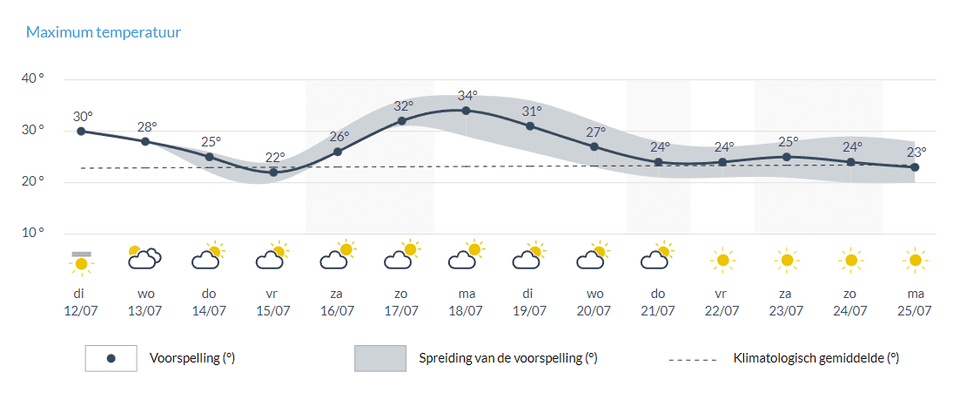
got hot. Too warm. In the coming days we will have to deal with temperatures above 30 degrees, and in the next week it may rise to 35 degrees.
Sophie Josens
In the UK, the weather service has announced code orange for the upcoming weekend. There are “exceptionally high temperatures, which can have widespread consequences for people and infrastructure.” In our neighboring countries, the Netherlands and Germany, there are also warnings about tropical temperatures that could lead to a heat wave. To the south, in France and Spain, they are already at extreme temperatures. In France they have been battling with wildfires for several days, and on Monday temperatures in Spain soared above 40 degrees again.
We also will not make an exception. “It’s not unusual to see this kind of weather in Europe in July,” says Nicholas Rose of NoodweerBenelux. “We owe this to the low pressure area over southwest Portugal. This will drive and transport tropical air from North Africa. It hits Spain and Portugal first, where they expect temperatures between 40 and 45 degrees. At the end of this week and beginning of next week, these will extend heat to the rest of Europe.”
Read also. ‘Make sure you drink enough’: Frank Debusser predicts sweltering Ghent festivities
Hottest spot: Westhoek
In the next couple of days we’ll already get a preview. On Tuesday we start around 17-18 degrees, but by 4pm it will be 28-29 degrees for Uccle. Locally, it can also be from 31 to 32 degrees. “Usually it’s Kempin, but now it’s probably the warmest area out there,” Rose says. “It’s usually cooler up there across the North Sea, but now we see that the winds from the south are strong enough to stop the sea breeze,” he says. On Wednesday we will hit about 28 degrees.

On Friday we will have to deal with a slight drop in temperature. † © RMI
to retreat
Then it cools down a bit again. Thursday the thermometer will still show 25 degrees and by Friday the mercury will drop to 22 degrees. But then it will go up again and we will feel the heat from the Portuguese low pressure area. Sunday we will rise above 30 degrees again and Monday, perhaps the warmest day, the temperature can reach 35 degrees. The following days will also be warm.
This drop on Thursday and Friday can be explained by two consecutive areas of high pressure that follow each other, according to weatherman Frank Debusser. “The wind rotates clockwise around the high pressure area. If the high pressure area is west of our country, this means that the wind is coming from the north. This does not immediately cause great heat.” If the zone of high pressure is located in the east of our country, then the air will come from the south. It is much warmer. Now we have successive high pressure areas shifting from west to east. So the winds will change several times from the northern to the southern currents. As a result, we will “only” reach 22 degrees on Friday, after which it will be much warmer again. ”
Anyway, a period of intense heat is coming, says Debusser. “We always see periods like this associated with increased mortality. So make sure you check in with your parents and grandparents and make sure they can drink enough and find enough cool.”
Do we have a heat wave?
“It depends a bit. There are different definitions of a heat wave. Normally we use a period of five consecutive days with at least 25 degrees, three of them at least 30 degrees. This can work from Saturday. But for the same thing we’re going to get to just under 25 degrees. Next Wednesday,” Debusser says. Since it’s still too early to make predictions for the week ahead, Ross also calls it “looking at the coffee grounds” for now.

“Creator. Award-winning problem solver. Music evangelist. Incurable introvert.”


More Stories
British military spy satellite launched – Business AM
Alarming decline in the Caspian Sea
Lithuania begins construction of military base for German forces